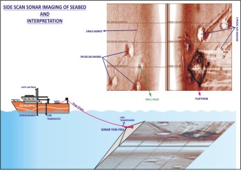
Side-scan imaging surveys use sonar to efficiently create a precise acoustic image of large areas of the sea floor. Side scan sonar uses transducers that emit fan-shaped acoustic pulses down toward the seafloor across a wide angle perpendicular to the path of the sensor through the water. Side scan sonar transducers may be towed from a surface vessel or mounted on the ship's hull. The intensity of the acoustic reflections from the seafloor of this fan-shaped beam is recorded in a series of cross-track slices. When stitched together along the direction of motion, these slices form an image of the sea bottom within the swath (coverage width) or slant range of the beam.
The sound frequencies used in side-scan sonar usually range from 100 Khz to 1 Mhz. Image resolution is a function of pulse length, the shorter the transmit pulse length the better the target resolution. Generally pulse length is selected to optimize resolution and range as the shorter the pulse length the less the slant range of the side scan image. Side-scan sonars are made with two transducers to cover both sides. The transducers are either contained in one hull-mounted package or within a tow fish and pulled by a tow cable in order to get closer to the bottom target of interest
Capabilities
Side scan sonars have several advantages, since they are commonly available at a relatively low cost and portable units can be easily deployed on small boats or ships of opportunity. This tool is used for mapping images of the seabed for a wide variety of purposes, including detection and identification of underwater objects and seafloor features.
Uses
Side scan may be used to conduct surveys for maritime archeology; in conjunction with seafloor samples it is able to provide an understanding of the differences in material and texture type of the seabed surface. Side-scan sonar imagery is also a commonly used tool to detect debris items and other obstructions on the seafloor that may be hazardous to shipping or to seafloor installations by the oil and gas industry. In addition, the status of pipelines and cables on the seafloor can be investigated using side-scan sonar. Side-scan data are frequently acquired along with hydrographic and sediment imaging data, thus providing a glimpse of the shallow structure of the seabed. Side-scan sonar is also used for fisheries research, dredging operations, environmental studies and has military applications including mine detection.
|